
This paper tackles the challenge of autonomous target search using unmanned aerial vehicles (UAVs) in complex unknown environments. To fill the gap in systematic approaches for this task, we introduce Star-Searcher, an aerial system featuring specialized sensor suites, mapping, and planning modules to optimize searching. Path planning challenges due to increased inspection requirements are addressed through a hierarchical planner with a visibility-based viewpoint clustering method. This simplifies planning by breaking it into global and local sub-problems, ensuring efficient global and local path coverage in real time. Furthermore, our global path planning employs a history-aware mechanism to reduce motion inconsistency from frequent map changes, significantly enhancing search efficiency. [Video:Bilibili]
Recently, we present APACE, an Agileand Perception-Aware trajeCtory gEneration framework for quadrotors aggressive flight, that takes into account feature matchability during trajectory planning. We seek to generatea perception-aware trajectory that reduces the error of visual-based estimator while satisfying the constraints on smoothness, safety, agility and the quadrotor dynamics. The perception objective is achieved by maximizing the number of covisible features while ensuring small enough parallax angles. Additionally, we propose a differentiable and accurate visibility model that allows decomposition of the trajectory planning problem for efficient optimization resolution (ICRA 2024 Submission). [Video:Bilibili]
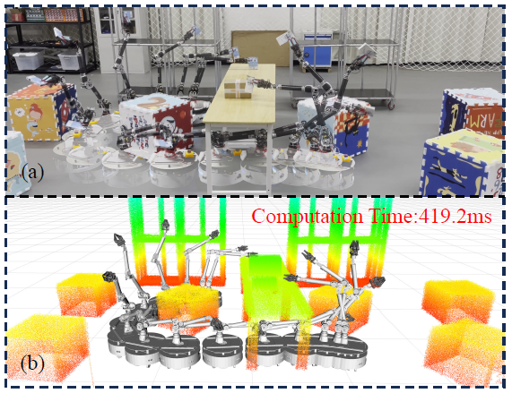
Mobile manipulators have recently gained significant attention in the robotics community due to their superior potential in industrial and service applications. However, the high degree of freedom associated with mobile manipulatorsposes challenges in achieving realtime whole body motion planning. To bridge the gap, this paper presents a motion planning method capable of generating high-quality, safe, agileand feasible trajectories for mobile manipulators in real time (ICRA 2024 Submission). [Video:Bilibili]
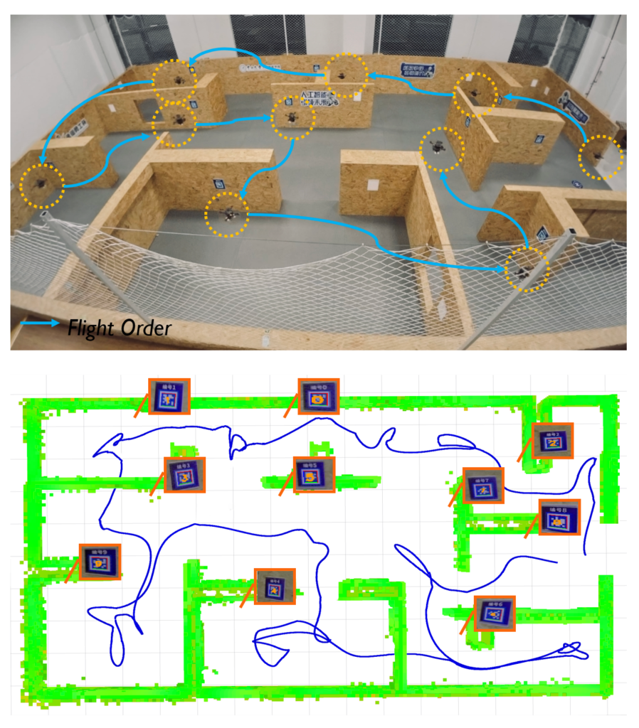
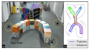
Recently, we propose FC-Planner, a skeleton-guided planning framework that can achieve fast aerial coverage of complex 3D scenes without pre-processing. We decompose the scene into several simple subspaces by a skeleton-based space decomposition (SSD). Additionally, the skeleton guides us to effortlessly determine free space. We utilize the skeleton to efficiently generate a minimal set of specialized and informative viewpoints for complete coverage. Based on SSD, a hierarchical planner effectively divides the large planning problem into independent sub-problems, enabling parallel planning for each subspace. The carefully designed global and local planning strategies are then incorporated to guarantee both high quality and efficiency in path generation. We conduct extensive benchmark and realworld tests, where FC-Planner computes over 10 times faster compared to state-of-the-art methods with shorter path and more complete coverage (ICRA 2024 Submission). [Video:Bilibili]
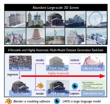
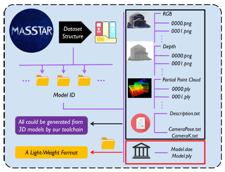
Recently, we propose MASSTAR: a multi-modal large-scale scene dataset with a versatile toolchain for surface prediction and completion. We collect a large amount of scene-level models including part of real-world captured data from a wide range of open-source works. A toolchain is also developed to facilitate processing the data by segmenting the raw 3D data and selecting the valuable model from raw 3D data and generating multi-modal data including RGB image, descriptive text, depth image, and partial point cloud. Additionally, we benchmark different algorithms trained on our dataset (ICRA 2024 Submission). [Video:Bilibili]
Recently, we propose a NeRF-based mapping method that enables higher-quality reconstruction and real-time capability even on edge computers of handheld devices and quadrotors by Chenxing JIANG and Hanwen ZHANG. Specifically, we propose a novel hierarchical hybrid representation and a coverage-maximizing keyframe selection strategy. Extensive experiments show our method achieves superior mapping results with less runtime compared to existing NeRF-based mapping methods. To the best of our knowledge, our method is the first to run a NeRF-based mapping method onboard in real-time.[Paper][Video:Bilibili][Video:Youtube][Code]
Recently, we developed a real-time planning method for UAV payload system considering the time-varying shape and non-linear dynamics to ensure whole-body safety and dynamic feasibility by Haojia Li. Additionally, an adaptive NMPC with a hierarchical disturbance compensation strategy is designed to overcome unknown external perturbations and inaccurate model parameters. Extensive experiments show that our method is capable of generating high-quality trajectories online, even in highly constrained environments, and tracking aggressive flight trajectories accurately, even under significant uncertainty. [Video]


Recently, we further develop a fully decentralized approach for exploration tasks using a fleet of quadrotors. The quadrotor team operates with asynchronous and limited communication, and does not require any central control. The coverage paths and workload allocations of the team are optimized and balanced in order to fully realize the system’s potential. The associated paper has been published at IEEE T-RO. [Paper][Video][Code]


Our recent work toward fully automated and highly efficient aerial reconstruction, published at ICRA 2023, by Chen Feng. [Paper][Code][Video]

